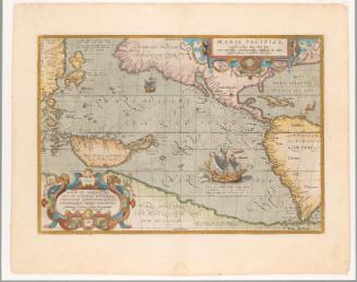
Abbreviated Map of All the World's Nations
「世界萬国之畧図」 版画 江戸後期
Despite regulations banning foreign travel, Japan had a welldeveloped mapmaking tradition throughout the Edo period (1615–1868), and world maps based on European models were available as early as the seventeenth century.
Maps like this one, a double-page illustration from a nineteenth century woodblock-printed book, allowed viewers to visualize the long passage from Japan to the West. Though titled as a map of the world, it focuses on the Pacific Rim nations: Japan is shown next to the pink Asian landmass at upper left, with the vast expanse of the Pacific between it and the landmasses of the Americas, which are pictured in gray at the right side.
An oceangoing vessel and a compass marked with the twelve Japanese zodiac signs show attention to navigation and shipbuilding in the era before Japan built its own maritime fleet, and before travel to the West had become commonplace.